 ENEA Antarctic Data Center
Talos dome
Type of resources
Topics
INSPIRE themes
Keywords
Contact for the resource
Provided by
Formats
Representation types
Update frequencies
status
Scale
-

The TALos Dome Ice CorE (TALDICE) is a European ice core research project (Italy, France, Germany, Switzerland, United Kingdom) aimed at retrieving an ice core reaching back through the previous two interglacials (about 250,000 years), from a peripheral dome of East Antarctica, and want to reconstruct a reliable chronology, thanks to the presence of numerous layers of volcanic dust given the proximity of several volcanoes. Talos Dome is an ice dome (159°11'E - 72°49'S, 2316 m asl) on the edge of the East Plateau of Antarctica, about 290 km from the Southern Ocean, 250 km from the Ross Sea, 275 km from Mario Zucchelli Station, 550 km North of Taylor Dome , 1500 km NW of Simple Dome, and 1100 km East of Dome C. The TALDICE project started in the field in November 2004 and ended on December 23, 2007, at the final depth of 1620.20 m. Ice Thickness 1795 m Mean annual temperature -41°C Mean annual atmospheric air pressure 721±10 hPa Ice velocity 0.14 m yr-1
-
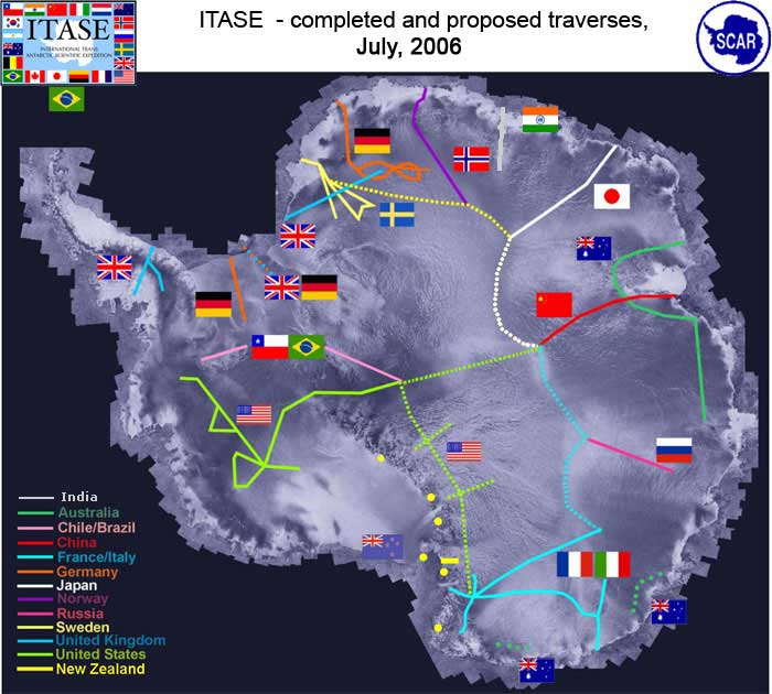
It is a program that, by means of surface crossings thousands of kilometers long, collects information on the behavior of the ice sheet and the related changes in the global sea level as a result of climatic and environmental changes over the last 200 years. Aims of the projects are: Determine the environmental variability in Antarctica over the last 200 yrs, and where the data are available the last 1000 years. Environmental proxies could include: sea ice variation, ocean productivity, anthropogenic impacts; and other, extra-Antarctic continental influences
-
The project aims to estimate the current mass balance of glaciers and in particular of the Antarctic ice sheet by studying the space-time variations of the balance of snow accumulation through the integration of meteo-climatic and glaciological data. Analysis of weather-climatic and snow measurements collected by AWS stations (Dome C, C3, High Priestley, Talos Dome and a Nansen Ice Sheet) using sensors for measuring snow transport and measuring poles. Snow radar data collection of the Dumont d’Urville-Dome C traverse. Analysis of the chemical and isotopic composition of the collected snow samples. Analysis of satellite data to define the path of the Talos Dome-Dome C-Vostok-Dome B-Dome A crosspiece. High resolution chemical / isotopic analyzes (samples in trenches) for the study of post-depositional diffusion / re-emission processes that occur in the part of the snow closest to the surface. Study of the spatial variability of the snow accumulation at the TD site and along the ITASE traverse. Continuation of the analysis of the samples and geophysical data collected in the previous ITASE traverses.